Mapping: Larimer Affordable Housing Planning
For the summer, I am interning with the Larimer Consensus Group (LCG), a community group that is creating a development plan for the neighborhood while keeping in line with goals of sustainable development, affordable housing, and community empowerment, building off receiving a Choice Neighborhood Grant for redevelopment and the Larimer Vision Plan.
“We want to develop a neighborhood, not just houses.”
I am creating maps that will help inform this process, combining existing county parcel data with tools to inventory properties on an ongoing basis, and eventually adding survey data. The challenge is to create maps that are easy for the public to understand while incorporating additional information needed for the planning process. This will be updated over the next few months. [full map with popup parcel details]
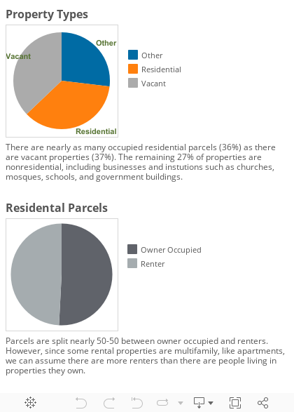
We can immediately see a wide distribution of residential, vacant, and 'other' properties, such as businesses, churches, and schools.
Like Pittsburgh as a whole, Larimer experienced a severe population decline, resulting in many vacant properties. The LCG's seeks to develop a master plan supporting a single family home strategy, incorporating maps and data with community input for a sustainable, affordable future.
The map below displays owner occupancy and renter data, gleaned from Allegheny County property data, based on address of owner on file. Property is assumed to be owner occupied if address of owner is same as property owner, and assumed to be renter if property is residential but owner has a different address.
This map also points out areas to target for the Single Family Housing Strategy -- areas that already have a high number of single family homes, good number of owner occupied properties, and medium to low number of vacant lots. Encouraging development on just a few lots in these areas could dramatically improve these highlighted streets. Full screen here.
This next map shows more detail. The light red parcels are single family homes, with dark red representing all other residential types -- multifamily homes, apartments, rowhouses, and more. Commercial business and offices are in blue, with governmental, educational, and religious institutions in purple. Click on a parcel to find more details about that property. You can also click on the three lines in the top left corner to hide or show the map legend, or use the magnifying glass to find a specific address. Full screen here
Lastly, the map below displays the cities of owners of property in Larimer, excluding Pittsburgh. While the vast majority are from Pittsburgh, and many more from areas just outside of the city, there are Larimer property owners across the country. Click on a city to see number of properties and average sale price of their properties.
This project is utilizing Carto and ArcGIS online and desktop for visualization and editing, R for data cleaning, Esri's Survey123 tool for community data, and Loveland's Site Control for updating parcel information.